
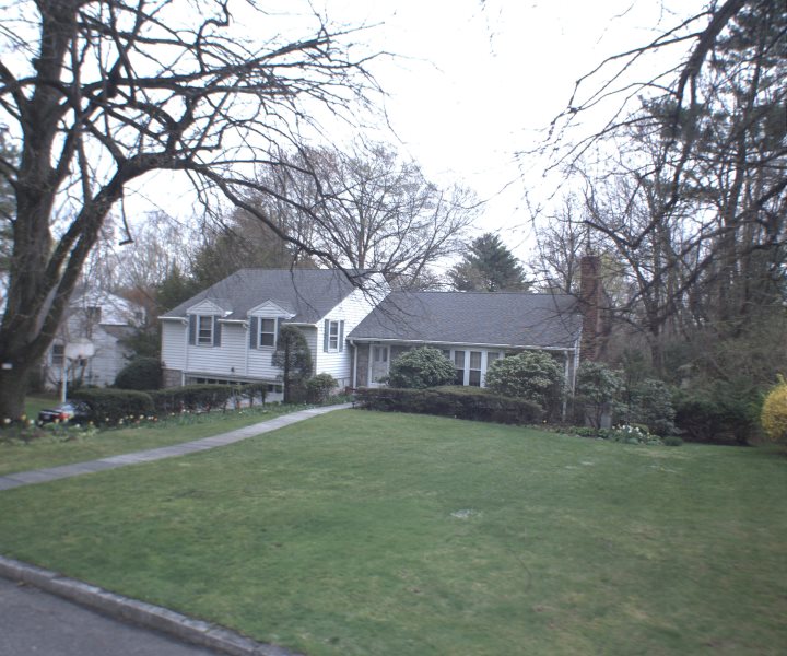
![]() Property Details - 117 CARTHAGE RD , SCARSDALE, 10583 - 22.12.17 - SWIS: 555000 (SCARSDALE)
Property Details - 117 CARTHAGE RD , SCARSDALE, 10583 - 22.12.17 - SWIS: 555000 (SCARSDALE)
View Property on GIS Map
Please select your parcel from the list on the screen opened from the map link.
Structure
| Building 1 | |
| Building Style | 03 - SPLIT LEVEL |
| Number of Stories | 1.0 |
| Exterior Wall Material | 03 - Aluminum\Vinyl |
| Actual Year Built | 1953 |
| Eff. Year Built | |
| Year Remodeled | 1980 |
| Number of Kitchens | 1 |
| Number of Full Baths | 3 |
| Number of Half Baths | 2 |
| Number of Bedrooms | 4 |
| Number of Fireplaces | 1 |
| Heat Type | 2 - Hot Air |
| Fuel Type | 2 - Gas |
| Central Air | Yes |
| Basement Type | 4 - Full |
| Total Sq Ft | 3154 |
| Finished Basement Sq Ft | 701 |
| Finished Rec Room Sq Ft | 340 |
| Finished Over Garage Sq Ft | |
| Condition | 3 - Normal |
Split level and raised ranch style homes include 1st floor basement in their SFLA.
2025 Assessment Information
| Land Assessed Value | $1,200,000 |
| Total Assessed Value* | $1,425,000 |
| Equalization Rate | 69.73% |
| Full Market Value | $2,043,597 |
*Total Assessed Value is used to calculate taxes.
Property Description
| Property Location | 117 CARTHAGE RD |
| Property Type | 210 - 1 Family Res |
| Neighborhood Code | 300 Heathcote |
| SWIS | 555000 |
| Water Supply | 3 - 3 |
| Utilities | 4 - Gas\Electric |
| Zoning | A2 20,000 SQFT |
| School | |
| Grid East | 0 |
| Grid North | 0 |
| Acres | |
| Front | |
| Depth | |
| Agricultural District | No |
| Account Number | 225143000 |
| Sales | |||||||||||
| Deed Date | Deed Book | Deed Page | Sale Date | Sale Price | New Owner | Prior Owner | |||||
|---|---|---|---|---|---|---|---|---|---|---|---|
No Exemption Data Found
| Land | |||||||
| Site # | Land Type | Acres | Front | Depth | Sq Ft | Soil Rating | |
|---|---|---|---|---|---|---|---|
| 1 | 01 - 01 | 0.60 | |||||
| Improvements | |||||||||
| Site # | Structure Code | SqFt | Dimensions | Quantity | Overall Condition | Actual Year Built | Effective Year Built | ||
|---|---|---|---|---|---|---|---|---|---|
| 1 | RP1 - PORCH, OPEN | 296.00 | 1.00 | 3 - Normal | 1953 | ||||
| 1 | LP7 - PATIO, FLAGSTONE | 534.00 | 1.00 | 3 - Normal | 1953 | ||||
| Special Districts | |||||
| Code Description | Type | Primary Units | Secondary Units | Amount | |
|---|---|---|---|---|---|
| CW501 - COUNTY SOLID WASTE | 0.00 | 0.00 | $0.00 | ||
| MS501 - MAMARONECK SEWER | 0.00 | 0.00 | $0.00 | ||
| Permits | ||||||
| Date | Type | Status | CO Date | CO # | Description | |
|---|---|---|---|---|---|---|
| 11/20/1989 | BUILDING | CLOSED | 8/8/1990 | 7574 | PMT : 12367-NEW ADDITION &NEW DECK * | |
| 4/29/1969 | SPRINKLER | NO CO REQUIRED | Zone : 3 EXISTING LINES | |||
| 4/27/1962 | BUILDING | OPEN | PMT : 06869 - ADDITION * | |||
| 6/10/1953 | BUILDING | CLOSED | 3/23/1954 | 2240 | PMT : 04951 - NEW DWELLING * | |